


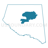
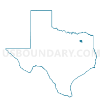
Voting District 0005, Rains County, Texas
About
Outline

Summary
| Unique Area Identifier | 676461 |
| Name | Voting District 0005 |
| County | Rains County |
| State | Texas |
| Area (square miles) | 24.28 |
| Land Area (square miles) | 22.91 |
| Water Area (square miles) | 1.37 |
| % of Land Area | 94.34 |
| % of Water Area | 5.66 |
| Latitude of the Internal Point | 32.89496950 |
| Longtitude of the Internal Point | -95.76967330 |
Maps

Graphs
Select a template below for downloading or customizing gragh for Voting District 0005, Rains County, Texas


Neighbors
Neighoring Voting District (by Name) Neighboring Voting District on the Map
- Voting District 0002, Rains County, TX
- Voting District 0003, Rains County, TX
- Voting District 0007, Rains County, TX
- Voting District 0010, Rains County, TX